Sol Duc River
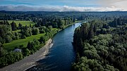
River in Washington, United StatesThe Sol Duc River is a river in the U.S. state of Washington. About 78 miles (126 km) long, it flows west through the northwest part of the Olympic Peninsula, from the Olympic Mountains of Olympic National Park and Olympic National Forest, then through the broad Sol Duc Valley. Near the Pacific Ocean the Sol Duc River joins the Bogachiel River, forming the Quillayute River, which flows about 4 miles (6.4 km) to the Pacific Ocean at La Push. Although the Quillayute River is short, its large tributary rivers—the Sol Duc, Bogachiel, Calawah, and Dickey Rivers—drain the largest watershed of the northern Olympic Peninsula, 629 square miles (1,630 km2). The Sol Duc's watershed is the largest of the Quillayute's tributaries, at 219 square miles (570 km2).
Read article


Top Questions
AI generatedMore questions
Nearby Places
Quillayute River
River on the Olympic Peninsula in Washington

La Push, Washington
Unincorporated community in Washington, United States
Quillayute Airport
Airport in Quillayute, Washington

Calawah River
River in Washington, United States

Dickey River
River in Washington, United States

Quileute Indian Reservation
Indian reservation in United States, Quileute

La Push Beach
Place in Washington, United States of America
Maxfield Creek
Stream in Washington, U.S.